Showing 423 items matching survey department
-
 Montmorency/Eltham RSL Sub Branch
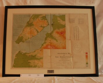
Map - Framed 1915 Map of Krithia, Gallipoli, 1915 Map of Krithia, Gallipolli, 1915
... survey department... captured Turkish maps by the Egyptian Survey Department. The main...Survey Department - Egypt... by the Egyptian Survey Department. The main feature is the Krithia ...A framed topographical map of The Dardenelles produced from captured Turkish maps by the Egyptian Survey Department. The main feature is the Krithia battlefield area in 1915.Krithia Peninsula (The Dardenelles) World War One - 1915 Mapworld war one, 1915, egypt, map, dardenelles, krithia, survey department, turkey, battlefields -
 Montmorency/Eltham RSL Sub Branch
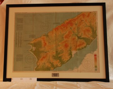
Map - Framed 1915 map of Sulva Bay, Gallipoli, 1915 Map of Silva Bay, Gallipoli, 1915
... survey department...Survey Department - Egypt... department battlefields egypt cairo Survey Department - Egypt ...This map was used in the Dardenelles Campaign 1915-1916.Framed map showing the Sulva Bay area of the Gallipoli battlefield in 1915.world war one, middle east, gallipoli, 1915, map, dardenelles, sulva bay, survey department, battlefields, egypt cairo -
 Montmorency/Eltham RSL Sub Branch
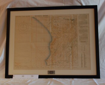
Map - Framed 1915 Anzac Cove Map, Gallipoli, 1915.ANZAC Cove Map, 1915
... of the Gallipoli Campaign, 1915, made by the Survey Department Egypt. Depth...Survey Department - Egypt... by the Survey Department Egypt. Depth soundings of landing areas off ...A framed map depicting trench lines and the battlefields of the Gallipoli Campaign, 1915, made by the Survey Department Egypt. Depth soundings of landing areas off Anzac Cove.Gallipoli - Anzac Cove World War One Map - 1915world war one, anzac, gallipoli, 1915, anzac cove, map, dardenelles, trench lines, depth soundings, landing areas -
 Flagstaff Hill Maritime Museum and Village
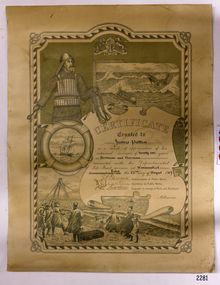
Award - Certificate of Service, F. W. Strahle, James Patten, 23-08-1907
... that was created by F. W. Strahle at the request of the Department of Lands...Department of Lands & Survey... Department of Lands & Survey Department of Life-Boat Service James ...This certificate acknowledges 21 years of service given by James Patten, one of the original 1859 Lifeboat Warrnambool as a boatman and bowman. At the time, all retiring Volunteer lifeboatmen were honoured with this award. It was made as a lithograph that was created by F. W. Strahle at the request of the Department of Lands & Survey, Melbourne, Victoria. During his time of service, James Patten was awarded a medal and certificate by the Royal Humane Society of Australasia for his bravery. Patten and his friend Joseph Lowe, who couldn't swim, were with their friend James Ferrier in a boat on the Hopkins River, Warrnambool, when their boat capsized. Ferrier made it to shore, and Patten tried unsuccessfully to hold onto Lowe and bring him to shore. The event occurred on 18th April 1890. The images on the Certificate show a collage of rescue events performed by the lifesavers; a shipwreck rescue in progress, lifeboat conveying five boatmen using two oars each, and a bowman standing at the bow, a linesman wearing a life jacket and holding a rescue line, a lifesaver ring with images of three sailing ships inside it, a shipwreck near shore, a woman and girl in shallow water, a rescue using a breeches buoy on the lifeline, two rescuers walking towards the survivor, rescue crew wearing waterproof clothing, a rocket machine with a pulley to bring the survivor in a breaches buoy to shore, and a rescue crew member holding a flare. Volunteers at the time received a small payment, or 'retainer'', for their practices and a payment of gratitude for the rescues they attended. Across the years between 1856 to 1979 the combined service in Victoria saved 260 lives. Amazingly, some of the volunteers could not even swim.This certificate shows the State and Local Government's appreciation for the years of service spent by in the endeavour to save lives in peril in and on the local waters in the early 20th Century. The lithographed design depicts the many skills and services performed by the lifesavers of the era.Certificate of Service, unframed, awarded to James Patten on 23rd August 1907, recognising his 21 years of service with the original Warrnambool Life Boat Service as a Boatman and Bowman. Certificate is on rectangular, cream paper, lithographed design, printed and handwritten. Letterhead with the Royal Coat of Arms of the United Kingdom and a French motto. Images depict lifesaving crew, lifeboat, rescue equipment and a rescue in progress. The border is waves inside of frame of looped rope. Signatures of Commissioner of Public Works, Secretary of Public Works, and Engineer in charge of Ports and Harbours, Melbourne. Printed from a lithograph produced by F.W. Strahle on 23rd June 1907.MOTTO: "Dieu Droit Et Mon, Ni Soit Qui Mal y" TREXT: "Certificate granted to James Patten as a mark of appreciation of his esteemed services of 21 years as Boatman and Bowman connected with the Departmental Life-Boat service at Warrnambool - dated the 23rd day of August 1907." SIGNATURES: [Commissioner of Public Works], [Secretary of Public Works], [Engineer in charge of Ports and Harbours Melbourne] "Lithographed at the Dept of Lands & Survey - Melb/ by F.W. Strahle, 23.6.07"flagstaff hill, warrnambool, flagstaff-hill, maritime museum, maritime village, shipwreck-coast, flagstaff hill maritime museum & village, james patten, life-saving, lifesaving, rescue, bravery, drowning, joseph lowe, james ferrier, hopkins river, boat accident, certificate of service, 1890, 1907, bowman, boatman, departmental life-boat service, life-boat service, lifeboat service, august 1907, commissioner of public works, public works, ports and harbours melbourne, lands & survey melbourne, f w strahle, lithograph, 1856-1979, 260 lives saved, victorian volunteers, lifeboatmen, retired lifeboatmen -
 Port Melbourne Historical & Preservation Society
Plan - Football Ground, Department of Survey & Lands, 13 May 1880
... Football Ground, Department of Survey & Lands... by Department of Survey & Lands, 1880... granted by Department of Survey & Lands, 1880 Sport - Australian ...Plan for Football Ground on land being granted by Department of Survey & Lands, 1880sport - australian rules football, sport - recreational grounds, j kitchen & sons pty ltd, port melbourne football club, pmfc -
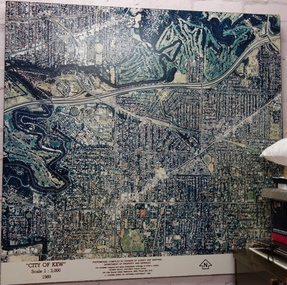 Kew Historical Society Inc
Photograph - Aerial Photograph, Division of Survey and Mapping, Department of Property and Services, City of Kew, Scale 1 : 3,000, 1989
... by Division of Survey and Mapping, Department of Property and Services...Division of Survey and Mapping, Department of Property and... by Division of Survey and Mapping, Department of Property and Services ...The City of Kew was a local government area about 4 kilometres east of Melbourne, the state capital of Victoria, Australia, on the southeast bank of the Yarra River. The city covered an area of 14.56 square kilometres, and existed from 1860 until 1994.Very large aerial photograph of “City of Kew” Scale 1 : 3,000. 1989. “City of Kew” Scale 1 : 3,000. 1989. Photomosaic compiled by Division of Survey and Mapping, Department of Property and Services. © Crown (State of Victoria) Copyright 1990.city of kew, kew (vic.), aerial photography -
Stawell Historical Society Inc
Archive - Maps, Victorian Government, Bailliere's Country Atlas of Victoria, 1866
... Under the Supervision of the Mining and Survey Department... the Supervision of the Mining and Survey Department Stawell is on Wimmera ...Stawell is on Wimmera & Loddon MapLarge Boxed Volume of Maps in Book Burgandy Coloured BoxUnder the Supervision of the Mining and Survey Department -
 Glenelg Shire Council Cultural Collection
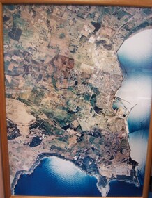
Photograph - Photograph - aerial view of Portland, 1988
... Division of Survey & Mapping, Department of Property... central Portland Portland Harbour Division of Survey & Mapping ...Census Project No. 1995. Portland Dec. 1988.Aerial view of the "City of Portland" and surrounding rural area to a scale of 1:10,000 Aerial Photomosaic of Portland Bay, 1988Front: (no inscriptions) Back: (no inscriptions)aerial photography, central portland, portland harbour -
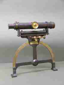
 City of Greater Bendigo - Civic Collection
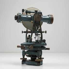
Instrument - Theodolite, Cooke, Troughton & Simms, c 1940
... Lands and Survey Department Bendigo... Lands and Survey Department Bendigo Cooke, Troughton & Simms. ...Theodolites are a highly accurate instrument that measures angles between designated visible points in the horizontal and vertical planes. The theodolite has a long history, with the term first found in 1571 in a surveying textbook 'A geometric practice named Pantometria' by Leonard Digges. (source https://en.wikipedia.org/wiki/Theodolite). Cooke Troughton & Simms began when John Troughton starting selling products in Fleet Street, London in 1782. He went into partnership with his brother Edward in 1807 who expanded the business considerably. William Simms, a former apprentice with the company was taken as a partner and then manager after Edward died in 1835 and the company became Troughton & Simms. By 1887 the company was able to produce all the parts necessary for their instruments and the company employed nearly 200 people and was one of the most well respected firms of instrument makers of the 1800's. James Simms, son of William who had inherited the company died in 1915 and the company was turned into a limited liability company by his two sons William and James. Things however were not so easy for the two sons and in 1922 the business was brought out by their rival T. Cooke & Sons becoming Cooke, Troughton & Simms. Theodolites are used by surveyors as part of their everyday work and although there is no specific information regarding the provenance of this particular one it is assumed it was used locally by the City of Bendigo and / or the Lands Department.A grey theodolite no 39161 made by Cooke, Thoughton & Simms. Various moving parts showing signs of extensive use particularly on the uprights on the main body and around knobs and dials where the paint is worn back to brass.Cooke, Thoughton & Simms Ltd / York. England / No 39161. Sticker; DPS - Asset No / (barcode) / 0010173city of greater bendigo administration item, lands and survey department bendigo -
University of Melbourne, Burnley Campus Archives
Document, 1979 - 81 Triennial Survey, 1978
... Boulevard Richmond melbourne Document 1979 - 81 Triennial Survey ...TAFEC Triennial Survey, Dept. of Agriculture Triennial Surveys for TAFE and CAE courses. 3tafec, triennal survey, tafe, courses, department of agriculture -
 University of Melbourne, Burnley Campus Archives
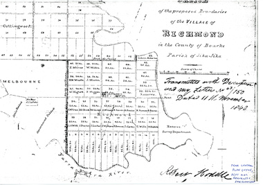
Plan - Sketch, Sketch of the Proposed Boundaries of the Village of Richmond, 1843
... as, "Reserve. Survey Department." From Central Plan Office, Department... Burnley Gardens site as, "Reserve. Survey Department." From ...Sketch of the proposed boundaries of the village of Richmond in the County of Bourke Parish of Jika-Jika. Handritten, "Transmitted with Descriptioon and my letter No 43/150 Dated 11th November 1843 Robert Hoddle." Shows Burnley Gardens site as, "Reserve. Survey Department." From Central Plan Office, Department of Natural Resources and Environmentrichmond, jika-jika, robert hoodle -
Whitehorse Historical Society Inc.
Map, Blackburn East Primary School
... Public 1979. Rolled map. Works Department detail survey.... 1979. Rolled map. Works Department detail survey. Public 1979 ...Works Department detail survey.Public 1979. Rolled map. Works Department detail survey.Works Department detail survey.blackburn east primary school no. 4800, victoria. public works department -
 Federation University Historical Collection
Instrument - Scientific Equipment, Miner's Dial, c1893 - 1901
... On suppliers label: "Instrument maker to the surveying... maker to the surveying and engineering departments of her ...Used for surveying classes at the Ballarat School of Mines. Purchased/acquired during Queen Victoria's reign. The 1893 Ballarat School of Mines Calendar states that mine surveying instruments "always at the disposal of the students" including "one miner's dial".A surveying instrument consisting of theodolite with single crosshair(.1) mountable on a magnetic compass (.2), designed to sit inside a polished wood carry box. Serial Number 4470On suppliers label: "Instrument maker to the surveying and engineering departments of her Majesty's Government of South Australia"ballarat school of mines, surveying, scientific instruments, scientific objects, otto boettger, optician, miner's dial -
 Orbost & District Historical Society
map/brochure, Discovering Marlo & The Snowy River Estuary, December 1988
... replaced the Department of Crown Lands and Survey, the Department... and Survey, the Department of State Forests and the Ministry ...In 1983 the Department of Conservation, Forests and Lands replaced the Department of Crown Lands and Survey, the Department of State Forests and the Ministry for Conservation. This brochure/map was used as tourist information in Orbost.This item is a useful research tool.A folded map/brochure titled "DISCOVERING MARLO & THE SNOWY RIVER ESTUARY". On the front is a photograph of Marlo and the title in yellow print. There is a locality map for access to Corringle beach and the brochure Includes a key to fishing sites and various tourist locations. On the back of the brochure are notes on fishing, wildlife and a boating guide, map brochure snowy-river marlo -
 Forests Commission Retired Personnel Association (FCRPA)
Beechworth FCV District office sign
... and Lands (CFL) along with the Crown Lands and Survey Department... and Lands (CFL) along with the Crown Lands and Survey Department ...This sign proudly hung outside the Forests Commission Victoria (FCV) Beechworth office which is now site of the Forestry Heritage Museum. The granite building in the Beechworth's historic precinct was once the Gold Warden's Office and is one of the town's original buildings. The FCV was the main government authority responsible for management and protection of State forests in Victoria between 1918 and 1983. The Commission was responsible for ″forest policy, prevention and suppression of bushfires, issuing leases and licences, planting and thinning of forests, the development of plantations, reforestation, nurseries, forestry education, the development of commercial timber harvesting and marketing of produce, building and maintaining forest roads, provision of recreation facilities, protection of water, soils and wildlife, forest research and making recommendations on the acquisition or alienation of land for forest purposes″. The Forests Commission had a long and proud history of innovation and of managing Victoria's State forests but in September 1983 lost its discrete identity when it was merged into the newly formed Victorian Department of Conservation, Forests and Lands (CFL) along with the Crown Lands and Survey Department, National Park Service, Soil Conservation Authority and Fisheries and Wildlife Service. After the amalgamation the management of State forests and the forestry profession continued but the tempo of change accelerated, with many more departmental restructures occurring over the subsequent four decades. Responsibilities are currently split between the Department of Energy, Environment and Climate Action (DEECA), Forests Fire Management Victoria (FFMV), Parks Victoria, Melbourne Water, Alpine Resorts Commission, the State Government-owned commercial entity VicForests and the privately owned Hancock Victorian Plantations (HVP).Large office sign. Hand painted in traditional FCV mission brown and gold colour scheme. -
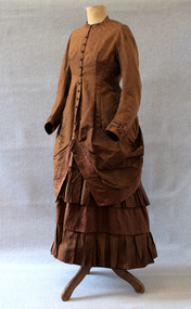 Brighton Historical Society
Clothing - Dress, Day dress, circa 1875-1876
... to his work in the Crown Land and Survey Department. The dress... to his work in the Crown Land and Survey Department. The dress ...This dress belonged to Ethel Nina Blundell (1876-1949), having been first made for her mother Jane Blundell (nee Burkitt, 1845-1878). Born in Dublin, Jane married James John Blundell Jr at the Black Street Congregational Church in Brighton on 16 March 1874. The Blundells were a socially prominent Brighton family who played an important role in the development of the area. James' father, publisher and bookseller James John Blundell Sr, served as a Brighton Borough Councillor between 1862 and 1867 when the local government was still in its formative years, including holding the position of Mayor in 1864. He was involved in the foundation of the Brighton Volunteer Rifle Corps and was also a strong supporter of the Brighton Ladies Benevolent Society. The Blundell family were active members of the Brighton Congregational Church and supported the construction of the Black Street church, where James Jr served as a deacon for sixty years, in addition to his work in the Crown Land and Survey Department. The dress is believed to have been made for Jane in 1875 or 1876 during her early pregnancy, likely by a local dressmaker. Jane died in 1878 when Ethel was very young, and Ethel was then raised by her father and paternal grandmother. As she never married, Ethel remained living in the family home of 'Eumana', 164 Church Street, and as an adult she assumed the role of hostess whenever she or her father had guests. On these occasions, she reportedly wore her mother's dress. The family home was sold on James Jr’s death in 1924 and Ethel was living at 52 Black Street Brighton when she died in 1949. In the 1930s, Ethel gifted the dress to a close family friend, Dr Jean Kelly. She told Jean that the garment held precious memories, perhaps due to the connection it provided to the mother she had never known. Jean donated the dress to the Merimbula Old School Museum in NSW in 1987, where it was on display for many years. The Museum donated the dress to Brighton Historical Society in 2023.This is a good example of a late nineteenth century day dress, made from two different patterns of russet brown silk brocade and featuring a lobster tail style bustle. The lack of boning combined with waist and hip measurements indicates it may have been made as a maternity dress. It is lined with beige leaf pattern cotton fabric. The princess line fitted bodice of herringbone pattern brocade has a high round neck with small 'mandarin' style collar and buttons down the front to below the waist where it forms an overskirt which is bordered with a band of coffee bean patterned brocade. The overskirt drops down to hem length at the back but from the centre front it is draped up to the back to a point below the waist level. Here it is sewn to the edge of the lobster tail style bustle which is also bordered by the coffee bean fabric. There is a concealed pocket with the opening under the right edge of the bustle. The buttons on the front of the dress have a decorative circlet of small blue flowers around a russet silk covered dome. The long sleeves are set in and slightly full with a contrasting three pleat band of coffee bean fabric with an ornamental turn back from the pleats sewn just above the wrist. The skirt section of the dress is in four 20 cm bands of alternate fabric patterns with the top and third band of coffee bean pattern slightly gathered and the second and fourth bands of herringbone forming pleated ruffles.1870s, ethel nina blundell, jane blundell, jane burkitt, eumana -
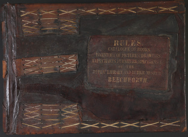 The Beechworth Burke Museum
Book - 1875 Catalogue, William Detmold, RULES / CATALOGUE OF BOOKS / INVENTORY OF PICTURES, DRAWINGS, / MAPS, CHARTS, FURNITURE, SPECIMENS / OF THE / PUBLIC LIBRARY AND BURKE MUSEUM / BEECHWORTH, 1875
... , that were given to the museum in 1868 by the Geological Survey..., that were given to the museum in 1868 by the Geological Survey ...This large, leather bound journal was made for the Public Library and Burke Museum in Beechworth by book manufacturer, William Detmold in 1875. It was commissioned by the President of the Library and Burke Museum committee, Dr Antoine Mousse, for the purpose of cataloguing all the items in the collection. The cataloguer was the curator at that time, William Morton, whose hand-writing appears in the journal today. When William Morton first started recording in this journal in 1875, there were already a number of existing items in the institution. The Public Library and Burke Museum in Beechworth had actually been operating since the 1850s; first as a Young Men’s Association in 1856, then as Beechworth Athenaeum in 1858, then as the Beechworth Public Library in 1860. Then in 1861 when news of the death of Beechworth’s former police superintended, Robert O’Hara Burke, reached the town, it was agreed that the Public Library would also become a museum to tribute his legacy, renaming it as the ‘Public Library and Robert O’Hara Burke Memorial Museum, Beechworth’. Many of the items from the early institutions would have been used to form the nucleus of this new organisation. Plus, the additional items that were either collected or donated to develop it into a museum. The catalogue is extensive. There are exactly 461 pages of recorded items, each page detailing the various collections the museum acquired in the late 19th century. Collections recorded in this catalogue include a large collection of geological specimens, that were given to the museum in 1868 by the Geological Survey Department of Victoria. A large collection of taxidermy mounts, that were given to the museum as skins by the Museum of Australia in 1865. An extensive collection of Aboriginal artefacts that were purchased from amateur anthropologist R. E . Johns in 1868. As well as artworks, charts, photographs, machinery, maps etc., all of which have been held in the museum since. This catalogue also details the governance and management of the organisation. There were originally 30 rules that governed the actions for the management committee and, while anyone could read in the free library, only subscribers could borrow two books and one periodical. At first, subscriptions rates were 7/6 a quarter. This was later changed to £1 per annum, paid quarterly in advance. This was a considerable amount; 7/6 per quarter meant that the annual fee was £1.10. This was equivalent to about £650.00 or about $1,182.00AUD today, while the reduced subscription fee of £1 a year was the equivalent to £450.00 or about $818.00AUD today. Membership of the athenaeum would have been the reserve of the town's notable citizens. The vale of the catalogue lies not only in its historical connect with the establishment of the Athenaeum and the current museum, but also in its record of the names and positions of all members of the institution's committees of management from 1875-1876. This is a unique object that contains important records for a notable country town. Large brown leather bound book made in 1875 for the Beechworth library and museum by William Detmond. Inside is a comprehensive and detailed itemised listing of the paintings, drawings, charts, photographs, specimens and books that entered the institution from 1850 -1882. non-fictionCover: RULES / CATALOGUE OF BOOKS / INVENTORY OF PICTURES, DRAWINGS, / MAPS, CHARTS, FURNITURE, SPECIMENS / OF THE / PUBLIC LIBRARY AND BURKE MUSEUM / BEECHWORTHburke museum, beechworth, catalogue, museum catalogue, 1875, william morton, william detmold, exposition universelle, ferdinand von mueller, public library, collection, book, leather bound, restored, digitised, robert o'hara burke, hand-written -
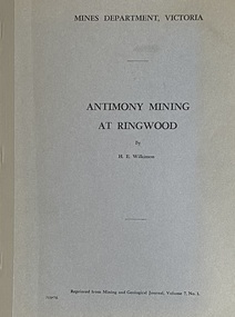 Ringwood and District Historical Society
Booklet - Mines Department, Victoria, Antimony Mining At Ringwood by H.E. Wilkinson, 1971
... and unpublished Geological Survey and Mines Department reports and Lease... and unpublished Geological Survey and Mines Department reports and Lease ...Between 1869 and 1892, the Ringwood antimony mines produced more than 3,500 tons of antimony ore, which represented bout 15 per cent of Victoria's antimony production for that period. Much greater amounts were later taken from the mines at Costerfield and the Ringwood mines lapsed into obscurity. Most of the information in this booklet has been obtained from published and unpublished Geological Survey and Mines Department reports and Lease Records. (See full list of references included). -
Tarnagulla History Archive
Set of Maps (Mining & Local Area), various
... . Geological Survey of Victoria, Department of Minerals and Energy.... Geological Survey of Victoria, Department of Minerals and Energy ...David Gordon Collection. A set of mining documents, maps and plans: 1. Dunolly Deep Leads - showing location and names of deep lead gold deposits in region around Dunolly including at Tarnagulla and Newbridge. Geological Survey of Victoria, Department of Minerals and Energy. Bulletin No. 62, Map No. 4 Dunolly (770 x 485 mm). 2. Poseidon Lead (Facsimile) 3. Nick O Time Lead (Facsimile) 4. Happy Go Lucky Mine prospectus and plan (colour copy) 5. Jones Creek GM Co. (Raven & Gourlay's) Waanyarra - Prospectus (colour copy) 6. Poseidon Area Plan (colour copy) and Poseidon Area map (B&W copy). 7. Cross-section diagram of Spread Eagle Reef 8. New Birthday Gold Mine - area map (colour copy) and mine cross-section ( (colour copy). 9. Cross section of Poverty Reef, by Department of Mines (B&W copy, 2 parts on A2 paper) 10. Time-Lease Graph for Watts Reef, Specimen Reef, Stony Reef, Poverty Reef (second page in detail), created by Eric WIlkinson for Ref Mining NL, 1995 11. 1859 Plan of the Gold Workings & Township of Sandy Creek, Shewing the Mining Leases, Extended Claims & Machinery by R.J. McMillan, Mining Surveyor (B&W copy) 12. Longitundinal and Transverse Vertical Sections of Poverty Reef, Sandy Creek 1859, by R.J. McMillan, Mining Surveyor (B&W copy) 13. Tarnagulla Locality Plan (B&W copy) 14. Universal Grid Reference Map (Topographic) for Laanecoorie North (2 copies) 15. Universal Grid Reference Map (Topographic) for Inglewood South 16. Poverty Reef, Plan showing shafts and early tenements, created by Eric WIlkinson for Ref Mining NL, 1995 17. Locality Map of mining leases in Tarnagulla 18. Plan and Elevation of part of Poverty Reef, Sandy Creek, showing the claims and positions of the shaft. by R.J. McMillan, Mining Surveyor (Facsimile, composed of taped together components) 19.Plan and Elevation of part of Poverty Reef, Sandy Creek, showing the claims and positions of the shaft. by R.J. McMillan, Mining Surveyor (Facsimile, composed of taped together components) -
 City of Moorabbin Historical Society (Operating the Box Cottage Museum)
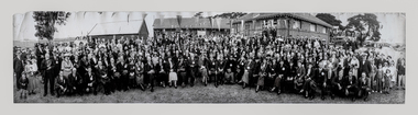
Photograph, B/W East Bentleigh SS No.2083 1925, 1925
The Common School No. 213 East Brighton 1864 - 1878 replaced the original St Stephen's Church of England School in Tucker Road. 1878-1908 the School was known as Education Department State School No. 2083 Brighton East. 1908 - 1936 the School changed it's name to Bentleigh and then from 1936 - 1993 was known as East Bentleigh. 1993 the school was closed due to low enrollments and the building was demolished and land sold . Charles J Coates, the father of Pam Thomas, attended this school.A school photograph of one of the original schools in the Bentleigh area showing a gathering of adults and children who had connection with this school either as teachers, pupils, parents or neighbours in 1925.A Black & White panoramic photograph of a group of adults and children in front of the classrooms of the East Bentleigh SS No. 2083 in 1925on back : handwritten 1925education, st stephens anglican school east brighton, education department state schools, state school number 2083, coates charles j, thomas pam, tucker road bentleigh, henry dendy special survey brighton 1841,market gardeners, dairy farmers, poultry farmers, early settlers, pioneers, tuck family bentleigh, moorabbin shire, moorabbin roads board, city of moorabbin, bent thomas, -
 City of Moorabbin Historical Society (Operating the Box Cottage Museum)
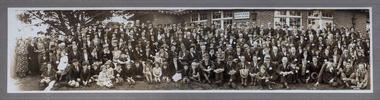
Photograph - B/W Bentleigh SS No.2083 1930, c1930
The Common School No. 213 East Brighton 1864 - 1878 replaced the original St Stephen's Church of England School in Tucker Road. 1878-1908 the School was known as Education Department State School No. 2083 Brighton East. 1908 - 1936 the School changed it's name to Bentleigh and then from 1936 - 1993 was known as East Bentleigh. 1993 the school was closed due to low enrolments and the building was demolished and land sold. Eric Hutchinson, the uncle of Les Hutchinson attended this school. A school photograph of one of the original schools in the Bentleigh area showing a gathering of adults and children who had connection with this school either as teachers, pupils, parents or neighbours in 1930.A Photograph , black & white panoramic showing group of adults and children in front of Bentleigh State School No. 2083 c1930 (Reprint) moorabbin, bentleigh, education department state schools, st stephens anglican school east brighton, hutchinson les, hutchinson eric, market gardeners, early settlers, pioneers, henry dendyspecial survey brighton 1841, east bentleigh state school no. 2083, coates charles j, bent thomas -
 City of Moorabbin Historical Society (Operating the Box Cottage Museum)
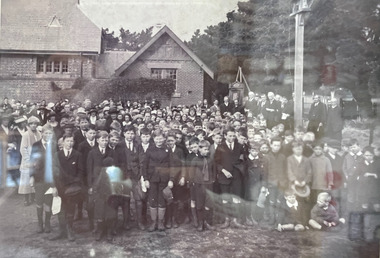
Photograph - B/W Bentleigh SS No.2083, 1920
The Common School No. 213 East Brighton 1864 - 1878 replaced the original St Stephen's Church of England School in Tucker Road. 1878-1908 the School was known as Education Department State School No. 2083 Brighton East. 1908 - 1936 the School changed it's name to Bentleigh and then from 1936 - 1993 was known as East Bentleigh. 1993 the school was closed due to low enrollments and the building was demolished and land sold. Eric Hutchinson, the uncle of Les Hutchinson, attended this school. Eric is second row far left ' behind the boy with the white handkerchief '. The 1920 gathering may be for the unveiling of a World War 1 Honour Roll - for past students killed or injured - as can be seen at the back of the group A flag pole may be the central wood post as all the boys and men have removed their hats and caps. A school photograph of one of the original schools in the Bentleigh area showing a gathering of adults and children who had connection with this school either as teachers, pupils, parents or neighbours in 1920.A black & White photograph showing a group of adults and children in front of Education Department State School Bentleigh no. 2083 in 1920 (Reprint)education, st stephens anglican school east brighton, education department state schools, state school number 2083, coates charles j, hutchinson eric, hutchinson les, tucker road bentleigh, henry dendy special survey brighton 1841, market gardeners, dairy farmers, poultry farmers, early settlers, pioneers, tuck family bentleigh, moorabbin shire, moorabbin roads board, city of moorabbin, bent thomas -
 City of Moorabbin Historical Society (Operating the Box Cottage Museum)
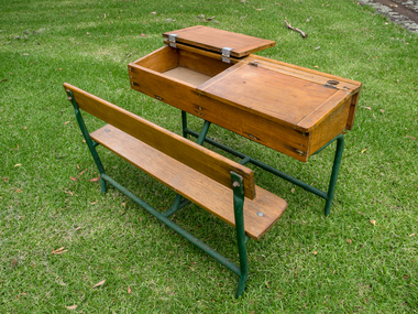
Education, 2 wooden 2 seat school desks c1950, c1950
Typical wooden school desks used c 1950 in Victoria Typical of school desks used by pupils in schools in Victoria c 19502 (two) wooden school desks with ink wells and lift up writing lids for 2 children A) Is on an iron frame with a bench seat b) is on an iron frame with 2 separate seats education, schools, early settlers, bentleigh, parish of moorabbin, city of moorabbin, county of bourke, moorabbin roads board, shire of moorabbin, henry dendy's special survey 1841, were j.b.; bent thomas, o'shannassy john, king richard, charman stephen, highett william, ormond francis, maynard dennis, market gardeners, vineyards, orchards, state schools victoria, marriott c, whelan k, cochrane a, east bentleigh state school 2083, -
 City of Moorabbin Historical Society (Operating the Box Cottage Museum)
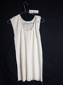
Clothing - Adult, Singlet wool nylon mix, Hospital, c1950
A nylon wool mixture sleeveless singlet with drawstring at neck that was possibly worn by George Reed when a patient at Heatherton Sanitarium c1950 "1909 'Consumption' or Tuberculosis was an infectious, debilitating disease. The main treatment of this ailment was a long period of rest, fresh air, sunshine and good food, so what better place to build a ‘Sanatorium’ than in the rural area they called Heatherton and affiliate it with the Melbourne Benevolent Asylum. After World War II c1947, the Commonwealth Government Health Department took over the Heatherton Hospital to deal with tuberculosis when it became a major problem in Australia. This was during the time when the Government conducted X-Ray surveys on a state by state basis. It was compulsory at that time for everyone to have a chest X-Ray. " ( KCC History Website 2020 , A.Bennett) Heatherton Sanitarium, situated in the City of Moorabbin, was the main rehabilitation hospital in Melbourne for patients suffering from 'Consumption' or Tuberculosis in 1909-1978 A wool / nylon mixture sleeveless Singlet with drawstring at neck that was used by George Reed at Heatherton Sanitarium c1950, Back neck ; ( ? Ward bed) 108Bclothing, singlets, underwear, heatherton sanitarium 1950, consumption, tuberculosis, rehabiltation, tb vaccine c1960, chest x-rays 1950, melbourne benevelont asylum cheltenham, brighton, moorabbin, pioneers, dressmaking, market gardeners, early settlers, craftwork, bentleigh, lacework, moorabbin shire reed george, dairy farms, fruit orchards -
 City of Moorabbin Historical Society (Operating the Box Cottage Museum)
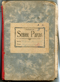
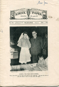
Magazine - The School Paper for grads VII and VIII (1920), c 1920
Issue no 242 - 253 of The School Paper Jan - Dec 1920, 12 Editions. This binder with copies of The School Paper was owned by W Marriott child of one of the pioneer families of City of Moorabbin,Issued by the Education Department of Victoria, printed Albert J Mullett, Government Printer, MelbourneThe School Paper For Grades VII and VIII (1920)EDUCATION DEPARTMENT VICTORIA / SCHOOL PAPER / For Grades V11 and VI11 (1920); Issue no 242 Ed. Dept of Victoria / Poetry Number education, victoria, australian history, victorian education department, marriott william, marriott geoff, market gardeners, pioneers, moorabbin shire, henry dendy special survey brighto 1841, east bentleigh state school no. 2083, wilfred marriott -
 City of Moorabbin Historical Society (Operating the Box Cottage Museum)
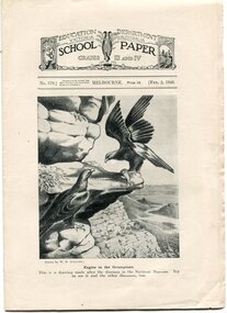
Magazine - The School Paper for Grades III and IV (1948) No 569 to 597; Feb 1948 to Dec 1948, 11 Editions, 1948
School Papers were issued to the children going to school in the state of Victoria by the Education Department for a cost of 1 penny per issue. These copies were collected and saved by one of the pioneer families of City of Moorabbin.Issued by the Education Department of Victoria, printed J. J. Gourley, Government Printer, Melbourne The School Paper For Grades III and IV (1948)EDUCATION DEPARTMENT VICTORIA / SCHOOL PAPER / For Grades III and IV (1948)education, victoria, australian history, victorian education department, marriott william, marriott geoff, market gardeners, pioneers, moorabbin shire, henry dendy special survey brighto 1841, east bentleigh state school no. 2083 -
 City of Moorabbin Historical Society (Operating the Box Cottage Museum)
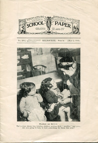
Magazine - The School Paper for Grades III and IV (1949) No 293 May and No 597 September, 2 editions, 1949
These School Papers were issued to the children going to school in the state of Victoria by the Education Department for a cost of 1 penny per issue. This copy was collected and saved by one of the pioneer families of City of Moorabbin.Issued by the Education Department of Victoria, printed J. J. Gourley, Government Printer, MelbourneThe School Paper For Grades III and IV (1949) 12 pagesEDUCATION DEPARTMENT VICTORIA / SCHOOL PAPER / For Grades III and IV (1949)education, victoria, australian history, victorian education department, marriott william, marriott geoff, market gardeners, pioneers, moorabbin shire, henry dendy special survey brighto 1841, east bentleigh state school no. 2083 -
 City of Moorabbin Historical Society (Operating the Box Cottage Museum)
Magazine - The School Paper for Grades III and IV (1950), 1949
These School Papers were issued to the children going to school in the state of Victoria by the Education Department for a cost of 1 penny per issue. This copy was collected and saved by one of the pioneer families of City of Moorabbin.Issued by the Education Department of Victoria, printed J. J. Gourley, Government Printer, MelbourneThe School Paper For Grades III and IV (1950) 12 pagesEDUCATION DEPARTMENT VICTORIA / SCHOOL PAPER / For Grades III and IV (1950)education, victoria, australian history, victorian education department, marriott william, marriott geoff, market gardeners, pioneers, moorabbin shire, henry dendy special survey brighto 1841, east bentleigh state school no. 2083 -
 City of Moorabbin Historical Society (Operating the Box Cottage Museum)
Magazine - The School Paper, Grades 5 and 6, No. 795 December 1968 and Grades 3 and 4, No. 809 December 1968, The last issue of The School Paper, 1968
These School Papers were issued to the children going to school in the state of Victoria by the Education Department for a cost of 1 cent per issue. These were the last edition of the School Paper to be printed. This copy was collected and saved by one of the pioneer families of City of Moorabbin.Issued by the Education Department of Victoria, printed J. J. Gourley, Government Printer, MelbourneThe School Paper For Grades 5 and 6 (1968) and For Grades 3 and 4 (1968)EDUCATION DEPARTMENT VICTORIA / SCHOOL PAPER / For Grades III and IV (1950)education, victoria, australian history, victorian education department, marriott william, marriott geoff, market gardeners, pioneers, moorabbin shire, henry dendy special survey brighto 1841, east bentleigh state school no. 2083 -
 City of Moorabbin Historical Society (Operating the Box Cottage Museum)
Photograph - Map of Dendy's Special Survey, 1852 Map of Henry Dendy's Special Survey of 1841, 19th Century
... at the department of Lands and Survey. /Melbourne. / Price 1/- ...Department of Lands and Survey, Melbourne....-Lithographed at the department of Lands and Survey. /Melbourne. / Price ...A Map drawn in 1852 that shows the 5,120 acres that formed Dendy's Special Survey of 1841. In 1840 Henry Dendy, a farmer in Surrey, England acquired a "Special Survey" from the Commissioners for Land and Emigration which gave Dendy the right to choose land in Port Phillip for the "bargain basement" price of only £1 per acre for 5120 acres, (an area of 8 square miles). The Special Survey also included the right to "the shipment of a worker for every £20 spent on land, whose free passage was paid by the Crown, equalling a total of 100 workers ". Accordingly Dendy sold his English holdings and paid the required £5120 and arrived in Melbourne in February 1841. However by this time land in the new colony was selling for £5 - £40 per acre. Because Henry Dendy possessed the order from the Colonial Office in London he was able to successfully oppose Governor LaTrobe's attempts to alter the price of the land. Dendy appointed Jonathan Were, (an entrepreneur, who had arrived in 1839), as his Manager and who later became a partner. Together, Dendy and Were decided on an area 5 miles south from Melbourne, bounded by North Road, East Boundary Road, South Road and to the west by Port Phillip Bay. Were and Dendy pitched their tents in the area now known as ' Park St, Brighton' and sank a well near the corner of 'St Andrew's St and Wells St'. By 1845 J.B Were and Company had bought almost half of Dendy's land and Were built himself "Moorabbin House" in Were St Brighton made from stone, quarried from local cliffs. It was still standing in 1924. Legend records Moorabbin is named after the Aboriginal word for ' Mother's Milk ' The soil is very fertile and well supplied with water especially in the area called 'East Brighton' - now known as Bentleigh and East Bentleigh - By 1850 the area had developed with numerous market gardens, dairy farms, fruit gardens and vineyards supplying food for the growing population of Melbourne.This Map shows the birth of the Brighton and Moorabbin area. On 18th January1859 Brighton was proclaimed a Municipality and a Borough by October 1863. Meanwhile, following a Petition, the area of East and South Brighton, incorporating Mordialloc, Cheltenham, Mentone, Sandringham and Oakleigh separated from Brighton to form the Moorabbin District Roads Board becoming the first Local Government Authority. Col. William Mair was elected as the first Chairman of the Moorabbin Roads Board. Moorabbin Shire 1871 developed further and was declared a City in1934. The City of Moorabbin was the largest Municipality in Melbourne before the Amalgamation of Councils in 1994 when it was divided in the south to City of Kingston and in the north to City of Glen Eira A Photo-lithographed 1852 Map showing the 5,120 acres that formed Dendy's Special Survey of 1841. Henry Dendy & Jonathan Were chose an area 5 miles south from Melbourne, bounded by North Road, East Boundary Road, South Road and to the west by Port Phillip Bay. Moorabbin County of Bourke / Photo-Lithographed at the department of Lands and Survey. /Melbourne. / Price 1/- brighton, moorabbin, bentleigh, cheltenham, dendy henry, bent thomas, were jonathan, special survey